B42 After: Visualising Transformation Through Aerial Rephotography
- info919885
- Mar 25
- 5 min read

There is something incredibly satisfying about watching a project come to life. Whether it’s a sprawling new housing development, the restoration of a historic landmark, or a massive infrastructure project, seeing a site transform from a muddy field or a derelict shell into a finished masterpiece is a journey worth capturing.
At fireFLY Aerial Innovation, we’ve always been obsessed with the "how" and the "why" of construction. But we realised that standard photography often misses the most important part of the story: the transition itself. That’s why we developed our B42 After service. It’s not just a collection of photos; it’s a precision-engineered storytelling tool designed to showcase change over time with absolute accuracy.
In this post, we’re going to dive into the world of aerial rephotography, why it’s a game-changer for marketing and project management, and how we use the latest enterprise drone tech to make it happen.
What is Rephotography?
The concept of rephotography is simple in theory but incredibly technical in practice. It involves taking a photograph of a specific location from the exact same vantage point, with the exact same framing, at different points in time. When you do this correctly, the transition between the "before" and "after" is seamless.
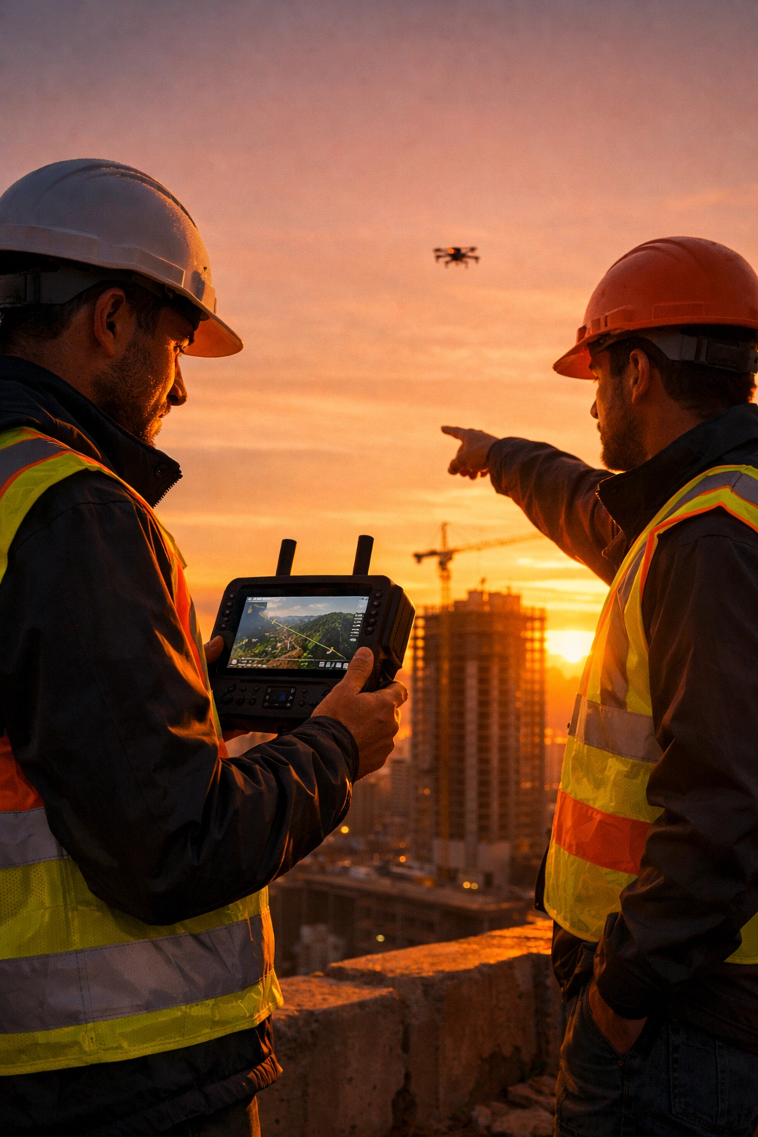
In the world of professional drone photography, this is a tall order. Winds shift, lighting changes, and even a few inches of deviation in the drone's position can ruin the effect. To pull this off, we don’t just "fly and hope." We use a range of professional DJI drones (including platforms like the DJI Mavic 3 Pro) and combine them with fixed waypoints so we can repeat the same position, height, and camera framing every time.
We also use RTK (Real-Time Kinematic) accuracy when precision is critical. That lets us record the exact coordinates and altitude of a shot down to the centimetre. When we return to a site six months later for the "after" shot, the drone can fly back to that precise point in space and re-run the same waypointed capture. This keeps the horizon, building angles, and perspective consistent, making seamless overlays and slider comparisons possible.
More Than Just Aerials: The Ground Perspective
While we are an aerial photography company at heart, we know that the story of a site happens on the ground too. B42 After isn't limited to the sky. We apply the same rigorous rephotography standards to ground-level shots. By using fixed markers or precision tripod placements, we capture "eye-level" transformations that resonate with people on a human scale.
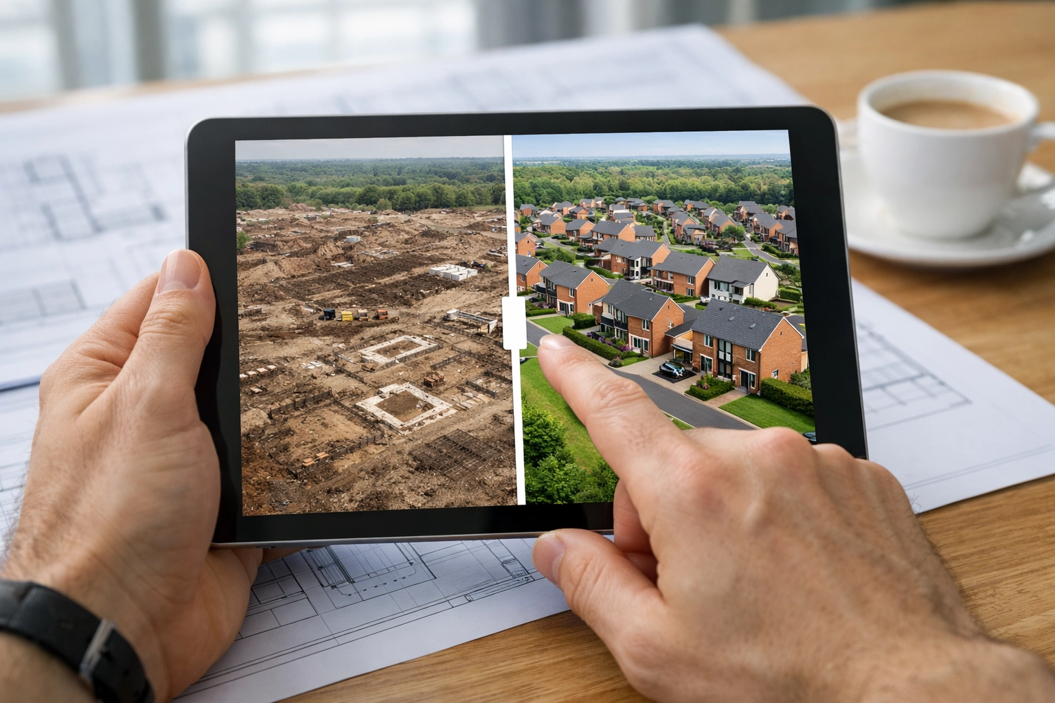
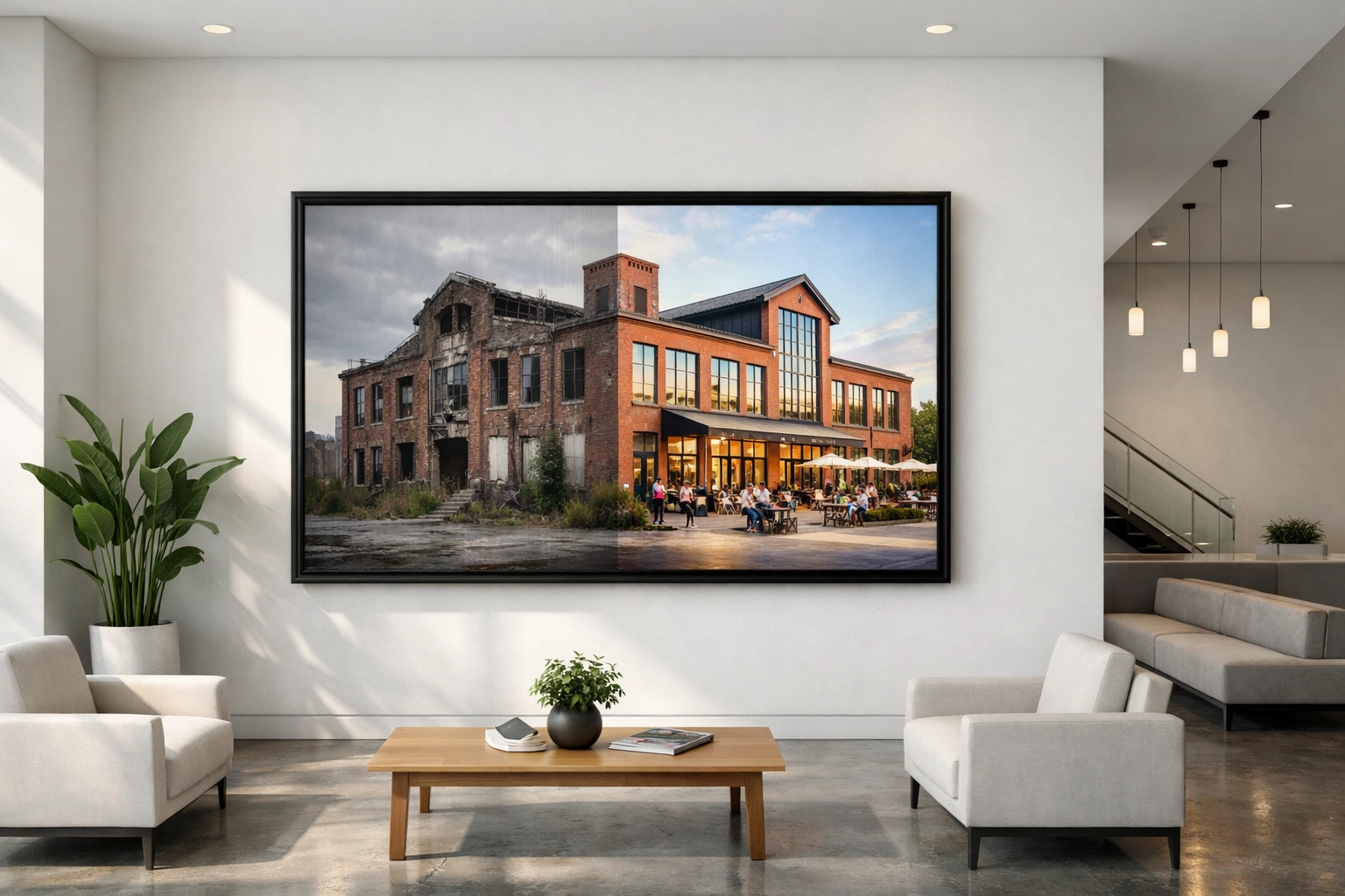
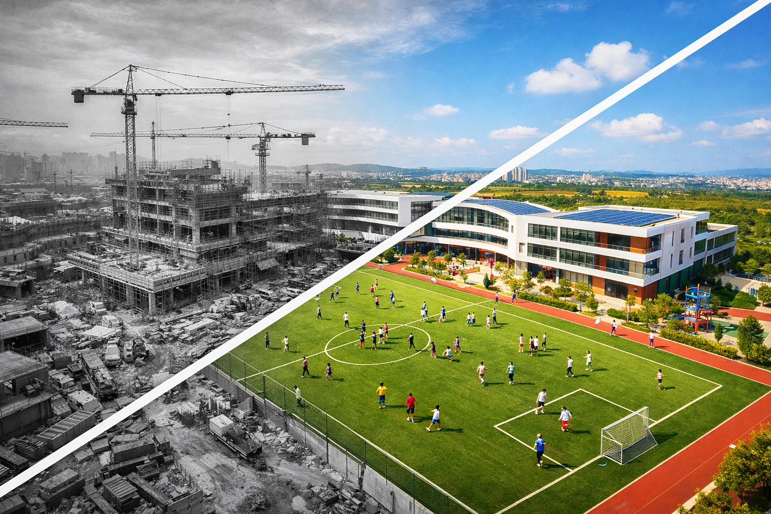
Interactive Storytelling: The Power of the Slider
Once we have captured these perfectly matched images, we don’t just hand over a folder of JPEGs and wish you luck. The real magic happens in how the content is consumed.
One of the most popular features of our B42 After service is the interactive slider. We host these directly on our platform, allowing stakeholders, potential buyers, or local residents to manually slide a bar across an image to reveal the transformation. It’s addictive, intuitive, and far more engaging than a standard "before and after" gallery.
You can see this in action on our B42 After page, where we showcase projects like the Houlton Civic Living development and Middlebeck Roads. For developers, these sliders are incredible assets for social media and website landing pages, keeping visitors on the site longer and providing a tangible sense of progress.
Time Trails: Bringing the Story to the Streets
We believe that the history of a site should be accessible to the people who live and work there. That’s where our Time Trails concept comes in.
Imagine walking through a newly finished development like Waterbeach and seeing a discreet, high-quality plaque on a wall or a bench. On that plaque is a QR code. When a passerby scans it with their phone, they are instantly taken to a dedicated page: like our Waterbeach Time Trail location: showing them exactly what stood in that spot years prior.
This "digital heritage" approach is a powerful way for construction and development firms to build goodwill with the community. It shows respect for the land’s history while celebrating its future. It turns a standard construction project into a landmark of local storytelling. You can explore more about this at fireflyai.com/timetrails.
Lenticular Prints: The Physical "Time Machine"
While digital tools are fantastic, there’s still something special about a physical object. For office lobbies, marketing suites, or heritage centres, we offer lenticular prints.
If you aren't familiar with the term, think of those "flicker" cards you might have had as a kid: the ones that change images as you tilt them. We take that technology and scale it up to professional gallery standards. As you walk past a large-scale B42 After lenticular print on a wall, the image shifts from the original site to the completed project. It’s a "wow" factor that never fails to start a conversation. It’s a physical manifestation of the transformation your team worked so hard to achieve.
Why Construction and Heritage Teams Need This
Our construction drone services are often hired for technical reasons: inspections, mapping, and site monitoring. But B42 After serves a different, equally important purpose: Communication.
Marketing & Sales: For developers, "selling the dream" is easier when you can show the reality of your track record. B42 After provides high-end visual proof of your ability to deliver.
Stakeholder Engagement: Large projects often face scrutiny from local councils or residents. Being transparent about the journey and celebrating the "After" helps build trust.
Heritage Preservation: For restoration projects, documenting exactly how a historic structure was saved is vital for archival purposes. It captures the craftsmanship that often gets hidden behind the finished walls.
Internal Pride: Construction is hard work. Having a high-quality visual record of what the team accomplished is a great way to celebrate milestones and boost morale.
The fireFLY Approach
We don't just fly drones; we provide solutions. When you work with us for B42 After, we consult with you to identify the key "hero" shots that will tell your story most effectively. We look at the sun’s path, the planned architecture, and the community impact to ensure every shot counts.
Using our enterprise-grade gear and post-production expertise, we ensure that every pixel aligns. Whether it’s a simple 2-step before and after or a multi-year chronological study, we handle the technical heavy lifting so you can focus on building.
Ready to Document Your Transformation?
If you’re working on a project that is going to change the face of a landscape, don’t let that transformation go unrecorded. Standard photos are a memory; B42 After is an experience.
From the precision of our professional DJI drone fleet (paired with fixed waypoint re-flights and RTK accuracy when needed) to the interactive sliders on your website and the QR codes on your site’s fences, fireFLY Aerial Innovation is here to help you tell your story.
If you want to see more examples of our work, check out our site map for a full list of project pages, or dive straight into our Houlton school gym transformation to see the level of detail we bring to every job.
Let’s capture the change together.
Ready to start your B42 After journey? Contact Paul and the team today to discuss your next project.
Comments